

Adventures in AI-Assisted Confirming: How Machine Learning is Revolutionizing Invasive Species Identification
- Taposh Mollick

- Dec 3, 2025
- 4 min read
iMapInvasives is a publicly accessible mapping system with the goal of centralizing and sharing invasive species data. Resource professionals and the public enter observations of invasive species online and through mobile apps by submitting a photo, coordinates, and the name of the species, with over 46,000 reports being submitted last year in New York.
When considering the verification process for invasive species reports within iMapInvasives, conventional methods involve extensive manual photo review by taxonomic experts. Our recent research has demonstrated that artificial intelligence (AI), specifically a type of machine learning (ML) called convolutional neural networks (CNNs), can significantly accelerate the verification process while maintaining accuracy. This enables specialists to devote more attention to complex cases that require advanced taxonomic discernment.
The system employs iNaturalist’s VisionAPI, an image recognition tool that analyzes photographic evidence and geolocation data to validate species reports. When confidence scores exceed calculated species-specific thresholds, reports can be automatically confirmed without human intervention.
Addressing the challenges of unconfirmed reports
New York's iMap platform receives hundreds of weekly submissions, resulting in substantial backlogs of unconfirmed reports. Even with the big network of expert reviewers, common species like Japanese knotweed frequently accumulate in verification queues, potentially delaying management responses to new infestations.

iMap tool for invasive species reporting and data management, showing unconfirmed species in the northeastern United States.
Creating an iMap Confirming Tool using Machine Learning
Our goal was to design a tool that would feed iMapInvasives (iMap) reports into an existing machine learning system. The iNaturalist image recognition model using CNN is trained on millions of labeled species photos, and has gained worldwide usage. However, while incredibly powerful, iNaturalist ML apps analyze one image at a time. To adapt it for high-throughput needs, we secured research access to VisionAPI and created a custom workflow tailored to iMap data.
The iMap confirming tool operates in three automated stages:
1. Data Extraction: Invasive species presence reports are pulled from iMap that include user-submitted photos, species labels, and geolocation data.
2. Model Processing: These reports are pushed through VisionAPI to generate predicted species labels along with composite confidence scores that account for both visual similarity and geographic range.
3. Decision Logic & Thresholding: For each of the 11 test species, we applied logistic regression models comparing predicted labels to expert-verified results. This statistical analysis established species-specific confirmation thresholds based on visual distinctiveness. Only reports for Tier 3 and 4 (well-established) species that surpassed these thresholds were considered eligible for automatic confirmation.
To ensure data quality, we implemented additional logic:
· If the VisionAPI prediction did not match the user-submitted label or if the confidence score was below the species threshold, the record was flagged for manual review.
· Records were also evaluated based on geo-score and NYS species tiers, with high-tier and high-confidence reports prioritized for confirmation.
This multi-step system enables automated filtering while maintaining human oversight for higher-risk reports. The outcome is a scalable, automated framework that integrates ML with domain-specific safeguards, paving the way to reduce the iMap backlog while preserving data accuracy.
To evaluate our iMap confirming tool, we ran 316 unconfirmed reports through it and manually reviewed each result. The tool recommended automatically verifying 33% (104 reports), with 97% precision. This efficiency gain enables experts to focus efforts on ambiguous identifications and high-priority species.
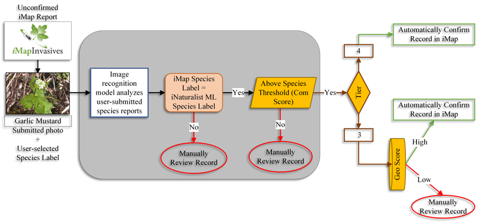
Machine learning workflow to iMap unconfirmed for automated verification of submitted species reports.
Advantages of using ML-based species identification
1. Speed without sacrifice
Automatically confirmed reports are immediately integrated into distribution maps, eliminating delays that might obscure emerging infestations.
2. Experts tackle the tough stuff
The system flags uncertain cases (e.g., low-quality images or taxonomic discrepancies) for manual review, ensuring specialists address only submissions requiring human expertise.
Enhanced detection capabilities
The developed ML tool demonstrated the capability to detect atypical species occurrences, including unfamiliar plant characteristics and insect-host interactions, warranting further expert review. During testing, the system successfully identified patterns such as insects observed on unexpected host plants and foliage exhibiting features indicative of invasive species. In this context, the model functions as an intelligent digital assistant, supporting early detection and species confirmation.

Examples of invasive species detected through ML: Spotted Lanternfly (left), Tree-of-heaven (center) and Hemlock Woolly Adelgid (right).
For instance, one submission featured a tree with morphological traits resembling sumac; however, the leaf structure corresponded to Tree-of-heaven (Ailanthus altissima). Upon closer inspection, the image also revealed an insect actively feeding on the host, which was subsequently identified as Spotted Lanternfly (Lycorma delicatula), with clear ecological implications.
Similarly, the system recognized early-stage infestations of Hemlock Woolly Adelgid by detecting characteristic white egg sacs clustered on the needles of hemlock trees. These nuanced identifications underscore the model’s value in enhancing early detection capabilities.
Each reviewed image presents an opportunity to identify not only the target species but also associated pests, hosts, and ecological interactions. This integrative perspective supports a more comprehensive understanding of invasive species dynamics and informs timely management responses.
The critical role of image quality
We found that image quality significantly impacts the tool’s effectiveness, with 84% of manually reviewed cases necessitated by suboptimal photographs. The model achieves highest accuracy with clear, well-composed images containing diagnostic features.

Examples of good photos or AI-friendly shots (left) and bad photos or AI-confusing shots (right) for ML image recognition species identification.
Photography guidelines for reliable AI verification
· Get close! Fill the frame with the species.
· Avoid blur – steady your phone.
· Capture key diagnostic features (leaves, bark, flowers).
· Simple background help.
· Include multiple specimens when possible
The tool produced by this project will help reduce the confirming backlog of common invasive species reports in iMapInvasives, plus speed up feedback to iMap users who submit these reports. To be considered for confirmation, an iMap report must be for a tier 4 species (well established across the state) and above the calculated species-specific threshold (meaning the model is very confident the image represents the species in question).
This machine learning tool isn’t replacing experts – it’s freeing them to focus on discoveries, outliers, and training the next generation of confirmers. Together, we’re building the fastest, smartest invasive species network yet.
Resources to Level Up:
· Join iMapInvasives today: Click here
· Access the ML GitHub code: https://github.com/tmollick95/iMapML
· Reporting observations in iMap: https://www.nyimapinvasives.org/report-an-invasive
Taposh Mollick is a graduate assistant at SUNY ESF, pursuing a PhD in Environmental Science. This project was completed as part of his Master’s degree program, with funding from the NYS Environmental Protection Fund and through the New York Natural Heritage Program.


